American Mining & Minerals, LLC
Brenda & Ana Maria Iron Mineral Reserves
I
II
III
IV
V
VI
VII
Geological & Extraction Summary – Brenda 500 – Mining Section – 1A
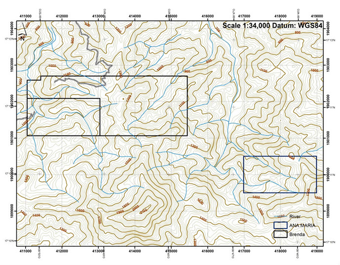
 This summary primarily concerns the operational mining plan and geological zone of Brenda 500 that shall herein be referred to as “Mining Section 1-A”. Having said that, the author will include a general overview of the total concessions consisting of Brenda 200, Brenda 500 and Ana Maria 200, for a total of 900 hectares, (2,250 acres) (See Map 1)
I – GEOLOGICAL HISTORY:
Brenda 200 and Brenda 500 are located in a strong intrusion zone as a result of two major fault lines that converge intersecting on the concessions (See Map 2) The Geological time period is from the Cretaceous 145 +/- 4 million years up to 66 million years ago, this age is followed by the Jurassic Period. Because of high temperatures and high sea levels, this period is known for Sedimentary Rock formations, worldwide, mostly chalk and limestone. Country Rock and Minerals located on Brenda consist of Sedimentary Host Rock of Limestone and Marble. Magma Uplifted Iron Minerals intruded the Sedimentary Host via Fractures stemming from the Fault Lines. Mineralization of Iron Units consists primarily of Magnetite Iron Minerals with varying Disseminations of Hematite. Magnetite Iron is magnetic, the materials may consist of mixed negative and positive magnetic poles, i.e. referred to as Loadstone, when attracting metal objects; Brenda contains ore bodies of both types of Magnetite Iron. Magnetite is one part Hematite (Fe203) and one part Ferrous Iron Oxide (Fe0) which makes Magnetite (Fe304). Magnetite is black to varying degrees of gray, the blacker the materials the higher the Fe0, and the lighter gray indicates lower Fe0 content within the ore. The uplifted Magnetic Fluids converged and formed the ore bodies, (See illustration Figure 1). The depth of Uplifted Magnetite Iron may be shallow if the Tectonic Plates have shifted away or in some cases in Mexico, maybe kilometers deep.
The Lower Sierra Madre Mountain range in the State of Guerrero is located within the Pacific Ring of Fire, and has not been developed for Iron Mineral Mining, primarily due to logistics. The Pacific Ring of Fire is the area that encompasses the Pacific Ocean with volcanoes, the entire Western Coast of the Americas and the Asian Coastal areas contain various Magma Uplifts caused by Faults / Fractures of the Earth’s Crust that allowed Molten Magnetic Liquids to rise to the surface and form seams, dykes and ore bodies. Mexico has an abundance of Fault Lines and varying areas of Magma uplifts. Brenda 200 and Brenda 500 are prime examples of Magma Uplifts, the value of Iron (Fe%) within the uplifted Iron of Brenda is of high value, “Grade A” Iron Minerals ranging from 62 to 69% Fe and will bring bonus premium price above the Platts 62 Fe% Bench Mark pricing on the China Seaborne Iron Ore Trade Route. (See Chemical Analysis)
There are four types of Iron Mineral deposits on Earth, Sedimentary, is the largest which are approximately 80% of all Iron Mineral deposits worldwide, and mostly Hematite; the second largest is Magma Uplifted Iron consisting primarily of Magnetite Iron Minerals, followed by “Hurled Iron” which is caused by large volcanic explosions and is isolated iron mineral deposits varying from a few tons to as much as 3,000,000 metric tons generally located within 100 kilometer radius of a large volcano, example would be the State of Colima, Mexico where there are many deposits of hurled Iron, however, they are generally too small to be commercially mined. The last and the least of Iron Mineral Deposits are Meteorites, there are several located within the Southwest, the largest being located on both sides the U.S. and Mexico border, in the States of Arizona and Sonora, however these iron floats are small and the area is not commercially viable for mining, it covers an area of approximately 20 square miles and is one the largest Meteorite Showers known in the Americas.
Mining Section 1A & Mining Section 1B
Brenda 500, Mining Section 1-A, is located on the top North by North West section of the concession, it is a single mountain surrounded by rivers and mountain streams. The crushing and laydown yard is located on top and in back of the mountain, included in this area is also the Waste dumper area which will hold approximately 2.8 million cubic meters of waste. (See Map 3) On Map 3, you may observe the blue line is the Land Usage Change, from Forestry to Mining, a total of 32.62 Hectares, that includes the crushing and laydown and waste dumper that will land fill the valley between the crushing yard and top of the back heavy haul road, see those areas on Map 3 as well. The blue dots with while circles are massive magnetite outcrops, totaling 123 in that section. (See the Outcrop Coordinates list herein)
On the southeast side of the mountain stream (Orange Line) is the lower elevation of the adjacent mountain, this area is also covered with heavy magnetite outcrops; this will be designated as Mining Section 1-B, see outcrops displayed on Map 4 and coordinates of those outcrops starting at number 123 to 148 on the list. The tonnage and of usable iron minerals on Mining Section 1-B and other mining sections including Ana Maria are not calculated herein as Mining Section 1-A is the designated first project and will take approximately 24 to 36 months to deplete, provided that the mineral does not exceed estimated depth.


Magnetic Contour & Associated Outcrops & Floats Mining – Section 1A
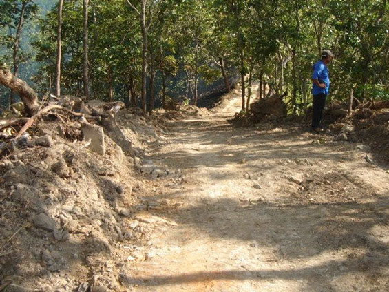
The selected area to open the mine was chosen based on several factors, those being primarily the easiest area to reach without a major undertaking of stripping the front of Brenda 500 and dealing with the River and water line to the village. It is also the fastest area that could be environmentally permitted, excluding any of the rivers and mountain streams. The back door approach turned out well using the old Carbonero State highway, which is 10.3km of Heavy Haul Road out to pavement. We have completed a rough cut and clean up so that the crushing yard can be driven too and will be within 100 meters or so from the top most outcrops. (See Map 5 Magnetic Contour) herein this map is 15,000 Milli-gauss contour lines [mGa]. Hand held Gauss Meter readings in this area has registered as high a 87.00 Gauss (87k mGa).

Magnetic Contour & Associated Outcrops & Floats Mining – Section 1A
In order to follow the block count density of iron, please view (Map 6, Magnetic Intensity Mining Section 1-A) On this map, the color chart indicates the response of magnetic measurement, the dark blue is the high point of magnetic intensity, ranging up to 70,000 mGa. Please note that this area is the heart of that section of iron mineral and the high intensity is represented by the Massive number of large surface Magnetite outcrops. (See Pictures of outcrops). Using conservative methodology in giving a reasonable estimate of metric tons of usable iron mineral without drilling conformation we will only use the centered 6 x 100 meter blocks with the highest magnetic density those blocks are located in Zone 14 Q UTM WGS 1984 (same as Google Earth) from North 1902+200 to 1902+400 meters and East 411+600 to 411+900 meters: This iron is Compact Iron and will average over 66% Fe, the specific gravity weight that most geologist use to calculate metric tonnage is 4.2, however, we will use the loose bulk weight for minus 2-inch (50mm) at 66% Fe, which will approximately be 3.8 metric tons per cubic meter. The following calculations include variables relating to the thickness of the materials and the percentage of usable iron within those 6 blocks, this will be a very conservative numbers as follows:
A.) Pessimistic Model using 20 meter depth and 65% usable materials within the 6 blocks:
200m x 300m = 60,000cm x 20m dp = 1,200,000cm x 3.8 lbw = 4,560,000 metric tons x 65% = 2,964,000 metric tons equivalent to 37 PanaMax Cargo Vessels at 80,000 wet metric tons.
B.) Moderate Model using 30 meter depth and 65% usable materials within the 6 blocks:
200m x 300m = 60,000cm x 30m dp = 1,800,000cm x 3.8 lbw = 6,840,000 metric tons x 65% = 4,446,000 metric tons equivalent to 55 PanaMax Cargo Vessels at 80,000 wet metric tons.
C.) Optimistic Model using 40 meter depth and 65% usable materials within the 6 blocks:
200m x 300m = 60,000cm x 30m dp = 2,400,000cm x 3.8 lbw = 9,120,000 metric tons x 65% = 5,928,000 metric tons equivalent to 74 PanaMax Cargo Vessels at 80,000 wet metric tons.
Viewing the outcrops and the amount of massive surface iron, there is the possibility that this block is the Magma uplift chimney and depth of the iron minerals may be from top to bottom of the mountain, over 200 meters in evaluation change.
Note: This author has looked at several hundred iron mineral deposits over the last 17 years, all over Mexico, Indonesia, Malaysia, Philippines, Tanzania, Liberia, U.S.A., Canada, and Costa Rica. Brenda and Ana Maria are some the best Greenfield Iron Mineral Deposits in Mexico and this will be a long term mining project; this is a Large High Quality Iron Mineral Mining Project.
V – Ana Maria Iron Mineral Deposit

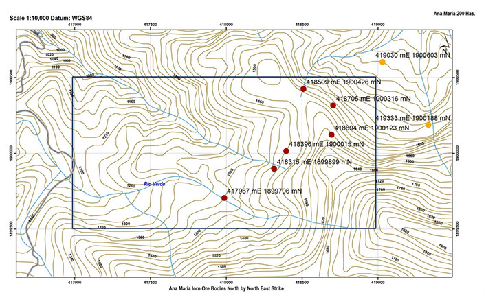
Ana Maria is much like Brenda but with a larger footprint, the Iron Mineral Strike is the same as Brenda and several other Iron Ore bodies in Guerrero on the North by North East heading between 30 and 35° which parallels the Fault Line on Map 1. (See Map 8) The strike runs north by north east for over 1,500 meters with a width of 700 to 800 meters. At this time we are currently conducting magnetic studies, and GPS recordings of the massive magnetite outcrops. We have constructed a road between Brenda and Ana Maria, to connect the two mines. Exploration of Ana Maria by our engineers and geologist has determined that it is a large magnetite ore body; Approximately 1 million tons of high grade magnetite ore is visible on the surface. Further studies by our engineers and geologist are being conducted before making any early assessments of the size of the iron ore bodies on this concession; our geologist estimate that there may be more than 10 Million tons of high grade ore at Ana Maria.

VI - Mining Plan Brenda 500 Mining Section 1A
At this time, a rough cut road has been cleared from the back of Brenda via the Carbonero road. There is a cleared area on the back top of Brenda, approximately 10 meters from the edge of the Crushing and Laydown yard Benching and Landing has been designed. (See Map 9) A 250 by 500 meter Bench and Landing Extraction Plan will be used together with 5 meter benches and 7 meter landings. It was decided to extend the landings out to 7 meters to try and prevent materials from falling down the steep mountain side and into the river. The equipment planned for extraction will be one Cat 365 Excavator with a 92-inch bucket, will be used to load trucks and move larger volumes of materials. A Cat 345 Excavator 76-inch bucket for digging. A Cat 336 ME with 76-inch bucket will load the crushing plant. A Cat 336 Excavator with a 3 ton hammer and two Cat 740 articulating dump trucks used to carry crush ready iron ore to the crushing yard. Two Cat 966 Wheel Loaders will be used to move finished ore and load trucks. A track drill will be used to drill the holes for blasting. Drill holes for blasting will be only 5 meters deep by 2.5 inch diameter; this is to prevent undercutting of the mine benches. Drill centers will be 36-inches, 30 holes at 150 meters total per shot, load and shoot contractor, and we will drill the blast holes.
Production is scheduled to run 28 days per month, with a 350mt per hour average. This production will provide 85% iron ore lump (6mm to 30mm) and 15% iron ore fines (0mm to 6mm).

VII - Logistics - Heavy Haul Trucking & Bulk Cargo Shipping
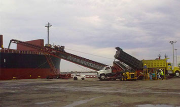
From the Crushing and Laydown Yard using the Carbonero Road, is 10.3km to the paved roads and 185km from Fed Hwy 95 to Puerto Vicente Guerrero (See Map 7). Initial shipping will be via 10,000dmt transfer barge out to a PanaMax near the mouth of the bay (See Map 10). Bulk Cargo Shipping is the highest Non-Mining Cost, and as the market tends to swing up and down, profits from shipping CFR China will increase the net via shipments of 80K/DMT PanaMax Class Vessels which generally are $10.00 to $15.00 dollars cheaper than a HandyMax at 40-45K/DMT.
